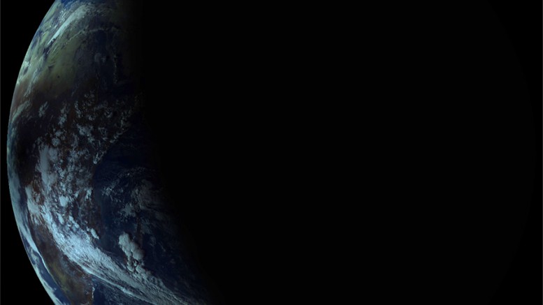
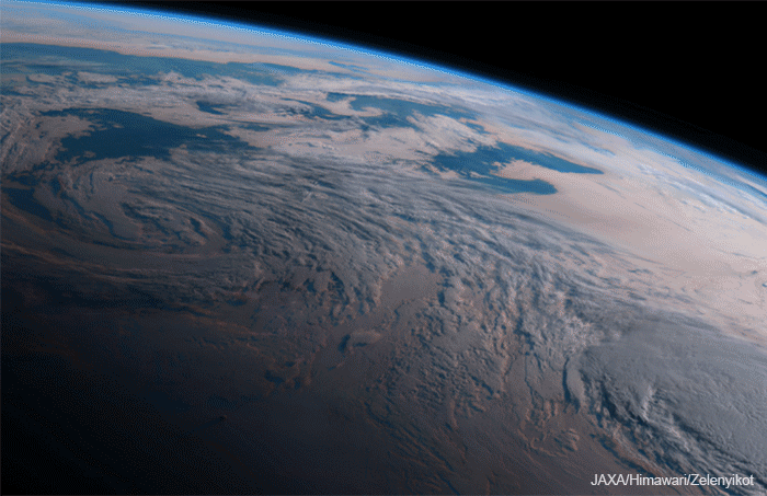
Yesterday, a lunar shadow passed across Africa and the Atlantic Ocean. This event was the last solar eclipse this year. The Electro-L satellite was able to observe the eclipse, and we can see how darkness covers Africa.
Electro-L is located in a geostationary orbit and takes the Earth every 30 minutes from the same point, from a distance of 36 thousand km. Therefore, we are presented with a unique picture that cannot be seen even from the International Space Station.
A terrible, mysterious event, which probably ensured the annual revenue of many African shamans, is a curious astronomical phenomenon for us, the people of the future.
(c) Rick Taylor
And as researchers should be, we observe it from the side.
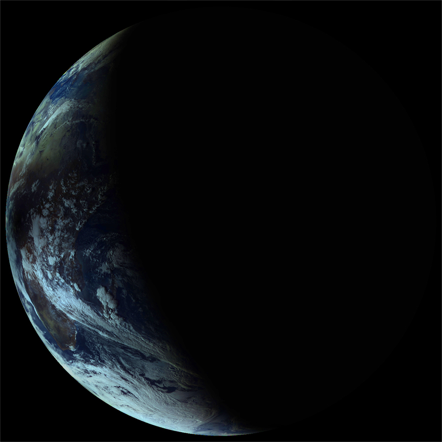
In May 2013, there was already a solar eclipse in Australia. Electro-L was also able to remove it. Moreover, at our request, Roscosmos changed the satellite’s operating mode , doubling the frequency of shooting. Thanks to this, we were able to better see the passage of the moon shadow across the mainland.
The African survey took place from a better angle and at the appropriate time of day, so the eclipse is clearly visible even without acceleration.
But now we are turning to Roscosmos with a more serious request – to launch a research probe on an asteroid. You can sign the petition . It is very easy to do through Facebook, but without it.
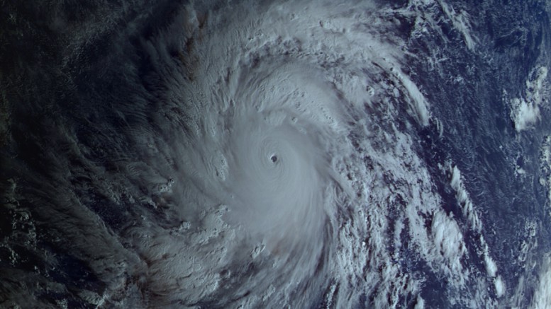
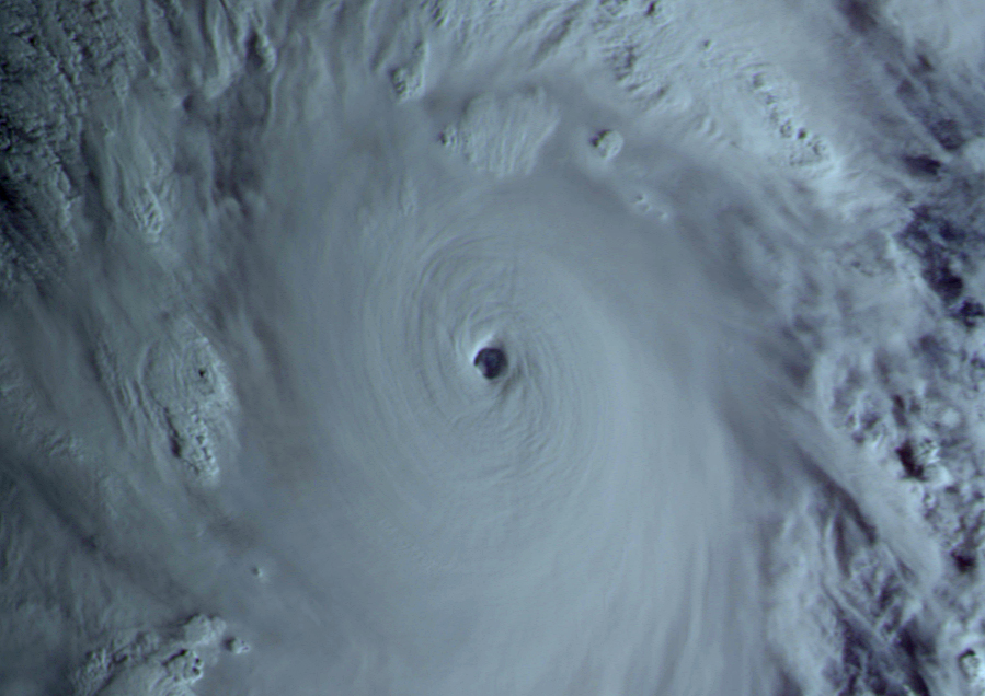
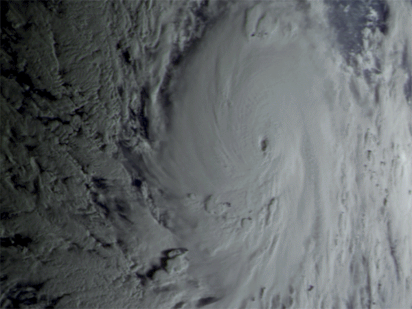
The Philippines hit typhoon Haiyan (Haiyan). More than 10 thousand died, tens of thousands lost their homes, millions had to be evacuated.
But we can enjoy the beautiful waltz of a deadly typhoon in the shooting of the Russian meteorological satellite Electro-L.
Thanks to a distance of 36 thousand km, the satellite observes the entire disk of the Earth, being above the Indian Ocean. The western part of the Pacific Ocean also falls into his field of vision. Therefore, we can observe the typhoons and cyclones that periodically collapse in Southeast Asia and the Far East.
Such a seemingly strange arrangement of the Russian satellite – over India, is not accidental. The geostationary orbit, which allows you to “hang in one place”, involves the placement of the spacecraft only in the equatorial plane. Therefore, Electro-L is located so that almost all of Russia falls into his field of vision, except for Kamchatka and the Far North.
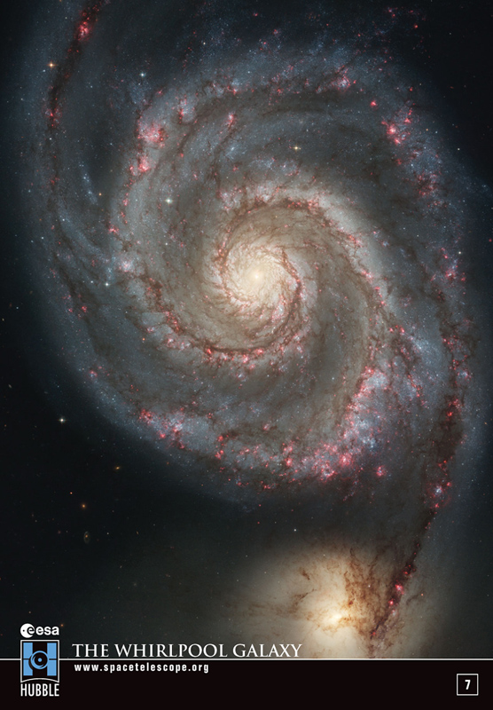
The satellite was created to observe the atmosphere and the processes taking place in it, so the cloud dance in its image can not be compared with anything … Although, when I did the “eye of the storm”, a striking resemblance to spiral galaxies came to mind.
Only in the center of the galaxy is a supermassive black hole, and the typhoon’s “eye” is formed as a result of the interaction of cold and warm air. The diameter of the “eye” is usually 50-60 km. From this photo you can imagine the overall scale of the event.
Satellite resolution 1 km per pixel.
Animation for three consecutive days was not easy, both for me and for the computer. I had to process simultaneously up to 70 images with a size of 15-40 mb. But the sleepless night was worth it, I think 🙂
Unfortunately, Russian media are not in a hurry to use satellite data from Electro-L, preferring to replicate images of Western or Japanese devices. I sent pictures from our satellite, but so far only American journalists from Universe Today have responded . This seems to me one of the problems of the Russian cosmonautics – everyone is in a hurry to write about disasters, and it is not interesting to show examples of successful work, even when there is a good reason.
A supermassive black hole in the center of our Galaxy usually behaves relatively calmly , however, recently astronomers detected a very bright flash produced by it (the brightness jumped about 75 times ,and then returned to its normal level). What is the reason , scientists do not yet know.
Here’s a timelapse of images over 2.5 hr from May from @keckobservatory of the supermassive black hole Sgr A*. The black hole is always variable, but this was the brightest we’ve seen in the infrared so far. It was probably even brighter before we started observing that night!
The supermassive black hole Sagittarius A * located in the center of the Milky Way is usually relatively calm, however, recently, in May, scientists, using the Kek Observatory in Hawaii, recorded unusual activity – the brightness in the near infrared increased significantly (approximately 75 times), and then returned to the previous level. What is the reason for such a strong increase in brightness? Now scientists do not have an exact answer.
Black holes themselves do not produce radiation that could be detected, but their environment emits because of the enormous friction generated by black holes by gravitational holes: this radiation is recorded by astronomers.
When the environment of a black hole greatly increases brightness, this may indicate that something came close enough to the hole and was captured by its gravity. What would this be in the case of the recently recorded outbreak of Sagittarius A * is not clear; at the same time, Sagittarius A * had the greatest brightness at the very beginning of observations, so it is possible that before that it was even brighter.
One of the possible explanations for such a strong jump in the brightness of the environment of Sagittarius A * is associated with object G2, which in 2014 approached a black hole 36 light-years away; it was supposed to be a gas cloud – but if that were so, the proximity to the black hole would have to break it and its parts would be absorbed by Sagittarius A *, but this did not happen. Perhaps the recorded outbreak is a kind of “belated reaction” of a black hole.
Do et al., ArXiv, 2019
Another explanation is related to the star S0−2 – located in a 16-year-old elliptical orbit around Sagittarius A *; last year, she made the closest approach to a black hole – at a distance of 17 light years. According to scientists, due to the close passage of S0−2 near Sagittarius A *, the way the gas enters the black hole could change; this may have led to more gas flowing and Sagittarius A * becoming more volatile.
Scientists hope to better understand what is still connected with a strong jump in the brightness of Sagittarius A *. The data from various telescopes that have observed the galactic center over the past few months can help with this.
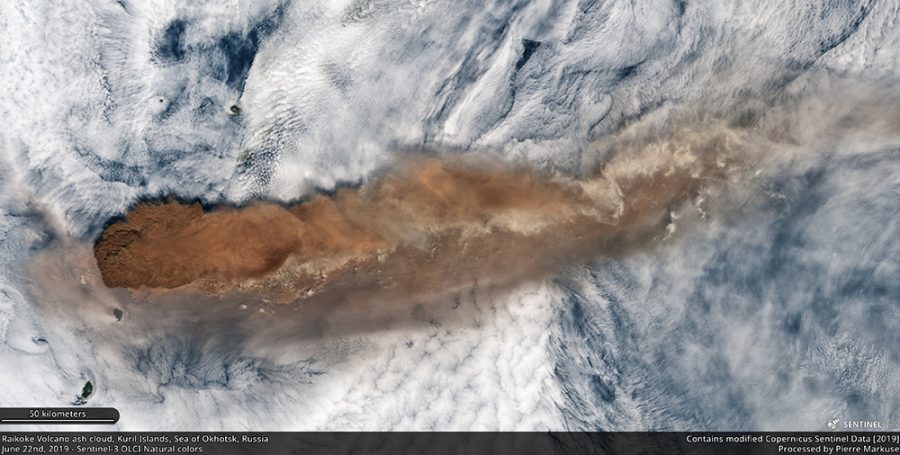
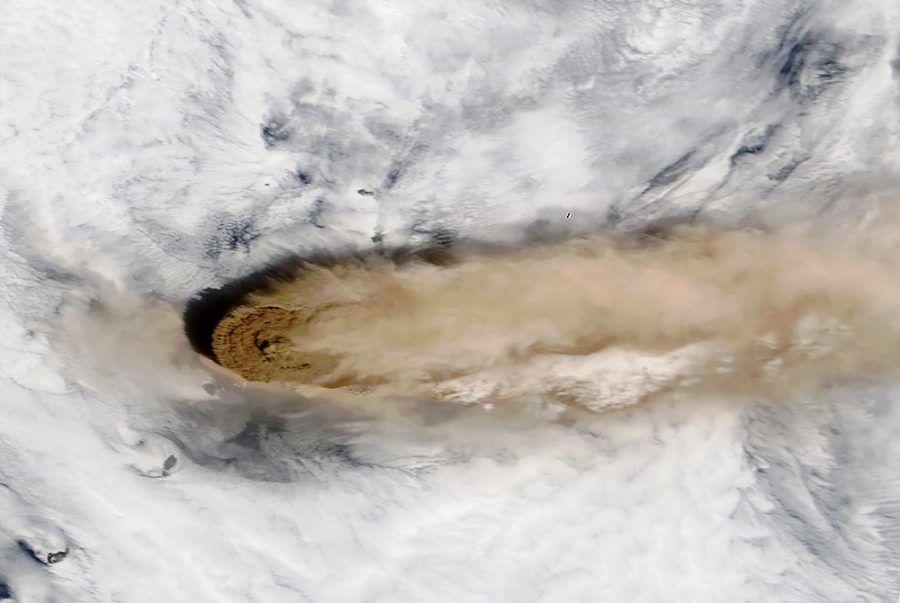
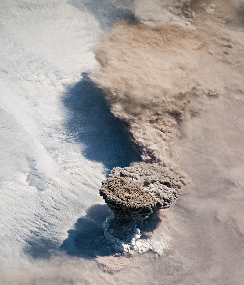
In the Kuril Islands there was a short-term, but powerful eruption of the volcano, which was accompanied by a large discharge of ash to a height of 15 km. Almost no one noticed the eruption, except for a few crews of ships in the Pacific Ocean, but several spacecraft could see this event from space. The ash trail of the volcano is a convenient occasion to get acquainted with the available means of monitoring the Earth.
Many meteorological satellites created by the largest space agencies are looking at our planet. Many of the results of their shooting are open to general use, and anyone can look at our common house from different angles and from different heights.
The European satellite Sentinel-3 flies at an altitude of about 800 km and shoots with a resolution of about 300 meters. His frame allows you to imagine the scale of the event.
Similarly, only a little later, the American satellite Terra took off the Raikoke volcano . Its flight altitude is about 670 km, and the resolution of images is up to 250 meters.
Russia has a series of Meteor-M satellites, but the data from them is available only upon request, or you need to set up your own receiving station . There are still devices of the Resource and Canopus series, but they also need a request. Roscosmos open data geoportal does not seem to be updated, at least there weren’t a single snapshot from June 22nd.
Much higher around the Earth, other meteorological satellites revolve – geostationary. At an altitude of about 36 thousand km, a satellite flying in the equatorial plane makes one revolution around the planet in 24 hours, i.e. it is always above the same point on the surface of the earth. This opportunity is often used by telecommunication and broadcasting companies, but there are also weather satellites there. Being in various “points of standing” they survey the planet each on its own side and are shooting with high frequency. So the Japanese satellite Himawari-8 is located in the most convenient place for observing the eruptions in the Kuril Islands.
Thanks to shooting with a period of 10 min, it is possible to see the entire process of eruption in a day.
Himawari-8 image resolution is 500 meters.
Russia also has one meteorological satellite in geostationary orbit – Electro-L2. The data from it is in the public domain , but, unfortunately, the recent eruption did not fall into the area of the survey.
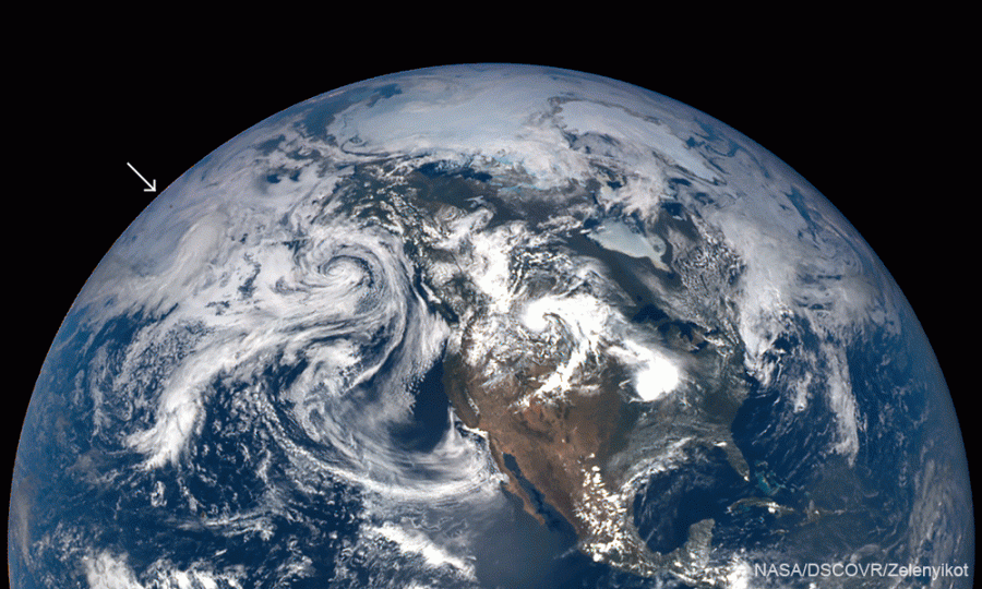
The most incredible thing is that this eruption turned out to be visible even from a distance of 1.5 million km from the Earth – it is four times farther than the moon. From this distance, the NASA camera on the DSCOVR satellite looks at our planet, its telescope always observes our planet from the illuminated side. The device is located between the Earth and the Sun in the so-called ” Lagrange point .”
Of course, these are far from all the satellites that capture the Earth. There are many spacecraft that observe with a much higher resolution of images, of their frames are Google and Yandex maps, they are used by military and civilian public services. But, as a rule, such satellites work according to a pre-written program, not for free, and remove only what they order, and events such as short-term volcanic eruptions do not fall into their program.
This eruption was also removed by the crew of the International Space Station.
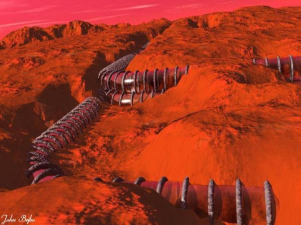
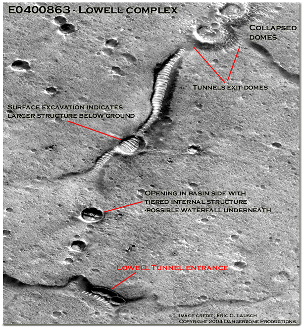
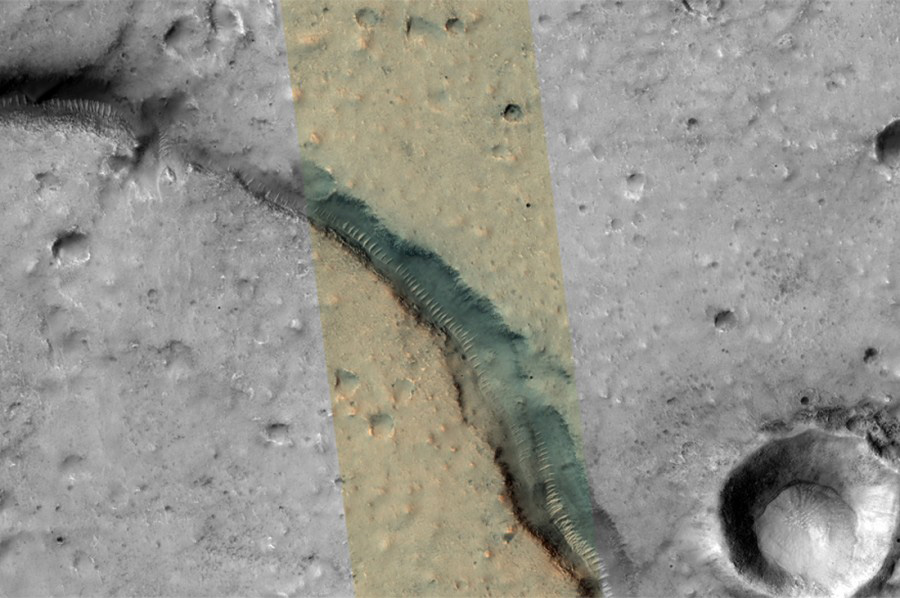
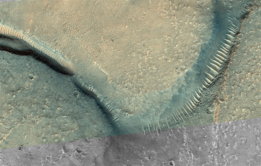
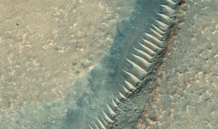
Today we’ll talk about another Martian legend, which appeared 10 years after the famous “face”, but did not gain such fame. The “Glass Metro” was examined in images of the Mars Global Surveyor spacecraft. At that time, this satellite had the most powerful camera and its research significantly enriched science with knowledge about the fourth planet. His own pictures gave rise to several new myths that did not allow Martian fans to sleep peacefully. Some frames revealed unusual landforms that seemed to some to be half-open (or buried) glass tunnels with transverse edges of the frame.
The logic of such assumptions is understandable: if life and civilization were not found on the surface, then it is necessary to look in the depths – there they hid. Until now, there have been periodic comments “We must drill deeper”, and even the “glass tunnels” were considered when the American Mars rovers were just starting their work.
Fortunately, we now know about Mars much more than 20 years ago. Now there are two rovers operating on the planet’s surface, which in total have traveled more than 50 kilometers, and the MRO satellite flies in orbit, which takes off the surface in a resolution inaccessible even for most near-Earth devices – up to 26 cm per pixel. Thanks to their research, one can already say with a considerable degree of certainty that on Mars there has never been a civilization, or even a complex organization of living organisms. Only microbes are still in doubt: whether they were, or were not.
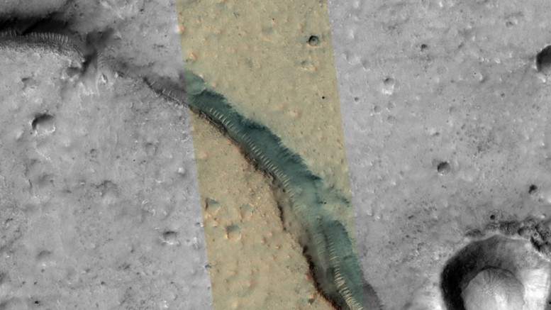
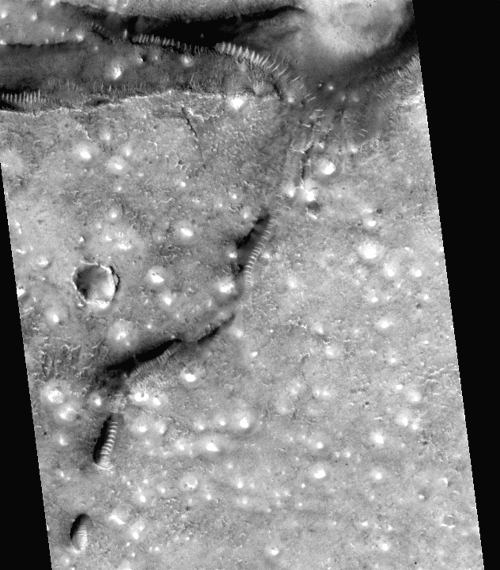
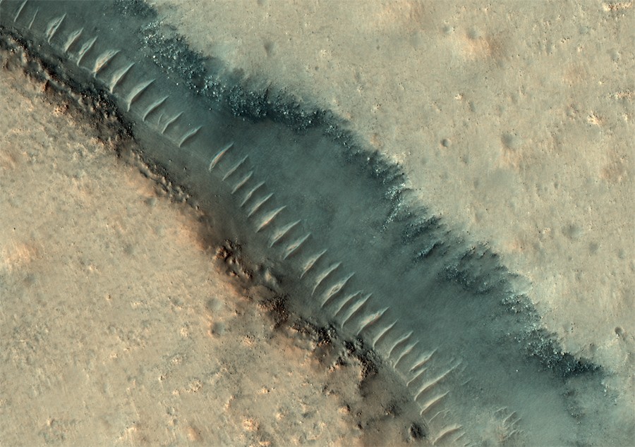
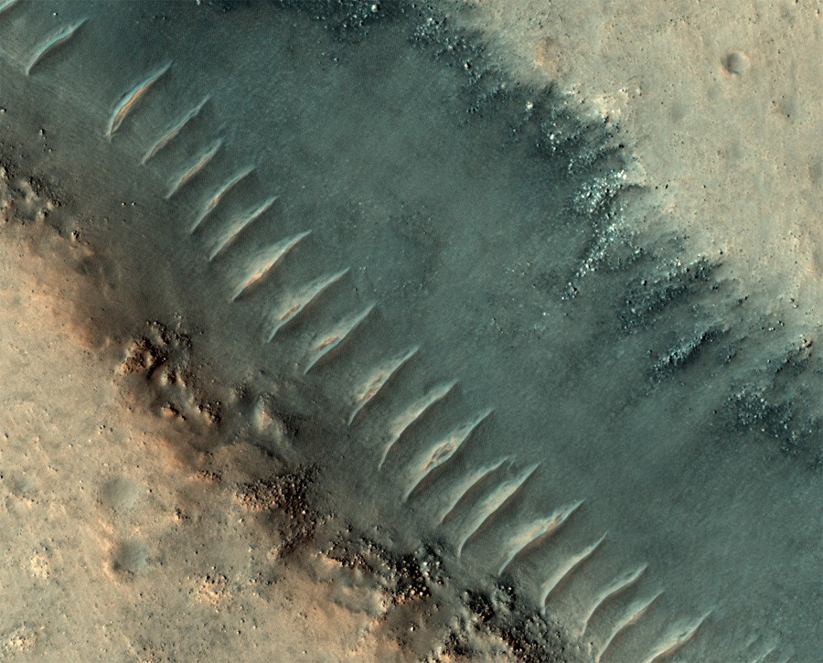
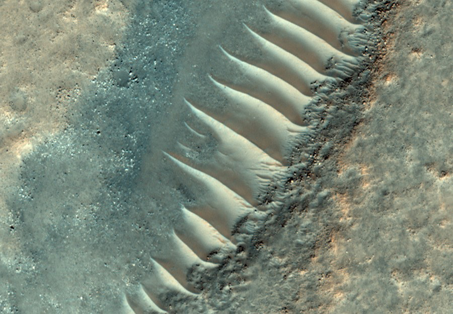
Thanks to MRO, we can see the glass tunnels much better and closer than before.
And even closer
And very close.
Once again:
As you can see, before us are not tunnels, but cracks, probably of volcanic origin, and the “frame” is just transverse sand dunes.
Thus, the “glass tunnels on Mars” is another wonderful demonstration of how the human imagination and desire for a miracle can cloud the brain, generating new myths of the 20th and 21st centuries.
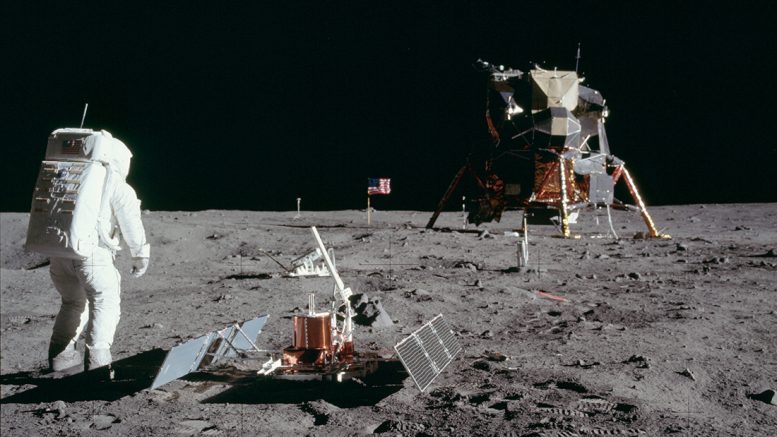
50 years ago, for the first time, man stepped into lunar regolith. This was the result of the fantastic progress of science and technology, the space race, the political confrontation of two countries: the USA and the USSR. A man’s flight to the moon has become such an incredible event that today many people deny the very fact of such a flight. Fortunately, thanks to the Internet, we have access to a huge amount of materials and scientific data that make it possible to independently find out the details of this complex program.
Landing places for lunar modules, automatic interplanetary stations, lunar rovers taken by the Lunar Reconnaissance Orbiter satellite: lroc.sese.asu.edu
Landing sites of Apollo 15 and Apollo 17 in the shooting of the Japanese spacecraft Kaguya, 3D reconstruction of landscapes taken by astronauts: kaguya.jaxa.jp
Apollo 15 landing site in the filming of the Indian spacecraft Chandrayaan-1 currentscience.ac.in
Of course, the Soviet and Chinese lunar rovers did not see the traces of Apollo, as they sat in other places, but they allow you to look at the Moon with “different eyes,” and compare it with American shots.
Archive of images of orbital panoramic and cartographic cameras that were installed on Apollo 15-16-17: wms.lroc.asu.edu (some of the links no longer work, but orbital images are available).
Images of stars and the Earth taken by the Apollo 16 ultraviolet telescope (Far Ultraviolet Camera / Spectroscope) from the moon’s surface (converted to modern image formats by amateurs from the NASA source files sent): archive.org/details/AS16-123
Scanned image catalog Far Ultraviolet Camera / Spectroscope: babel.hathitrust.org
Apollo lunar surface journal – a large archive of materials, photo-audio-film-full text of the negotiations during the mission. Apollo Landing Research Monographs: history.nasa.gov/alsj
The list of all sources, of course, is not limited to the above. Studying all the materials makes it possible to understand the enormous amount of work performed by people who decided to get to the moon.
I would like to draw attention to the efforts to publish the entire volume of historical materials: NASA, educational institutions, and amateur enthusiasts participate in this work. We can only dream of this, because a huge amount of materials from Soviet research programs is gathering dust in archives, inaccessible to Internet users. For example, panoramas of Lunokhods are published, but tens of thousands of television shots are not. A collection of images of the Moon from the Soviet “Probe-8” can only be seen on the website of the US Geological Survey , and this is not the only example when American enthusiasts and public services popularize Soviet space achievements more readily than ours.
I use materials on Apollo and other programs in my work on my book on the Apollo program and the popular questions that many people have on the Internet. I think this collection of links will be interesting to many. If you know any other useful official or unofficial resources on the Lunar program – share in the comments.